
By Chris Kirk
Posted Thursday, July 18, 2013
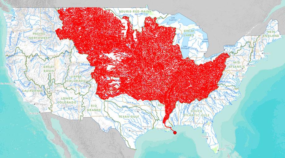
A new online tool released by the Department of the Interior this week allows users to select any major stream and trace it up to its sources or down to its watershed. The above map, exported from the tool, highlights all the major tributaries that feed into the Mississippi River, illustrating the river’s huge catchment area of approximately 1.15 million square miles, or 37 percent of the land area of the continental U.S. Use the tool to see where the streams around you are getting their water (and pollution).
Chart: Tributaries of the Mississippi River. - Slate Magazine
About nationalatlas.gov™ --> http://www.nationalatlas.gov/
If a picture is worth a thousand words, then a map is worth ten thousand. This is not like any atlas you remember.
Maps of America are what you'll find and make on nationalatlas.gov™. Maps of innovation and vision that illustrate our changing Nation. Maps that capture and depict the patterns, conditions, and trends of American life. Maps that supplement interesting articles. Maps that tell their own stories. Maps that cover all of the United States or just your area of interest. Maps that are accurate and reliable from more than 20 Federal organizations. Maps about America's people, heritage, and resources. Maps that will help you, your children, your colleagues, and your friends understand the United States and its place in the world.
This is nationalatlas.gov™, and it shows us where we are. It allows you to use your imagination and, by probing and questioning, to choose the facts that fit your needs as you explore the American story.
Background/History
For more information on preceding editions of the National Atlas of the United States®, visit American Memory, a terrific service of the Library of Congress.
In 1874, as the United States prepared its centennial celebration, the first national atlas was published under the title "Statistical Atlas of the United States Based on the Results of the Ninth Census 1870." Francis A. Walker, the Superintendent of the ninth census, was given authority by Congress to compile an atlas "with contributions from many eminent men of science and several departments of the government."
This was the Federal Government's first use of a bound collection of maps and charts to characterize Americans and their land. In addition to population maps, this first atlas presented economic and natural resources maps, including forests, precious metals, coal, climate, and crops. This early work was improved upon by Henry Gannett, who served as the Chief Geographer of both theCensus Bureau and the U.S. Geological Survey (USGS). He oversaw the production of the next three census atlases. The last "Statistical Atlas" was based on the 1920 census.
The next atlas was published 50 years later in 1970. The USGS led in the preparation of "The National Atlas of the United States of America." It was an oversized, 12-pound, 400-page book containing a collection of 765 maps. The maps in this atlas presented scientific information from a variety of Federal sources and depicted the principal characteristics of the country, including its physical features, historical evolution, economic activities, sociocultural conditions, administrative subdivisions, and place in world affairs. The 1970 atlas was expressly designed for use by decision makers in government and business, planners, research scholars, and others needing to visualize country-wide patterns and relationships between environmental phenomena and human activities.
The Government printed 15,000 copies of the atlas. It was offered at a price of $100, which-though reasonable based on its value-made it beyond the purchasing reach of most Americans. Libraries and schools bought 65 percent of the 15,000, commercial firms purchased 18 percent, foreign purchases accounted for 3 percent, and individual consumers bought the remaining 14 percent of stock. The atlas quickly went out of print and has been unavailable for purchase since the early 1970s.
Nearly 30 years passed before Congress authorized the preparation of a new national atlas in 1997. Once again, the USGS was assigned to coordinate and lead the effort of more than 20 Federal agencies. Nationalatlas.gov™ is the new National Atlas of the United States®. Like its predecessor, this new atlas provides a comprehensive, maplike view into the enormous wealth of geospatial and geostatistical data collected for the United States. It is designed to enhance and extend our geographic knowledge and understanding and to foster national self-awareness.
Unlike the big bound map collection of 1970, the latest National Atlas includes electronic maps andservices that are delivered online. We are using information presentation, access, and delivery technologies that didn't exist 30 years ago to bring you a dynamic and interactive atlas. But we have held fast to our tradition of producing the finest maps in the world. We think nationalatlas.gov™ is more useful than any bound collection of paper maps. Tell us what you think.
Production of the National Atlas is led by the National Geospatial Program of the U.S. Geological Survey.


No comments:
Post a Comment