

August 14, 2011

Show both images - Larger
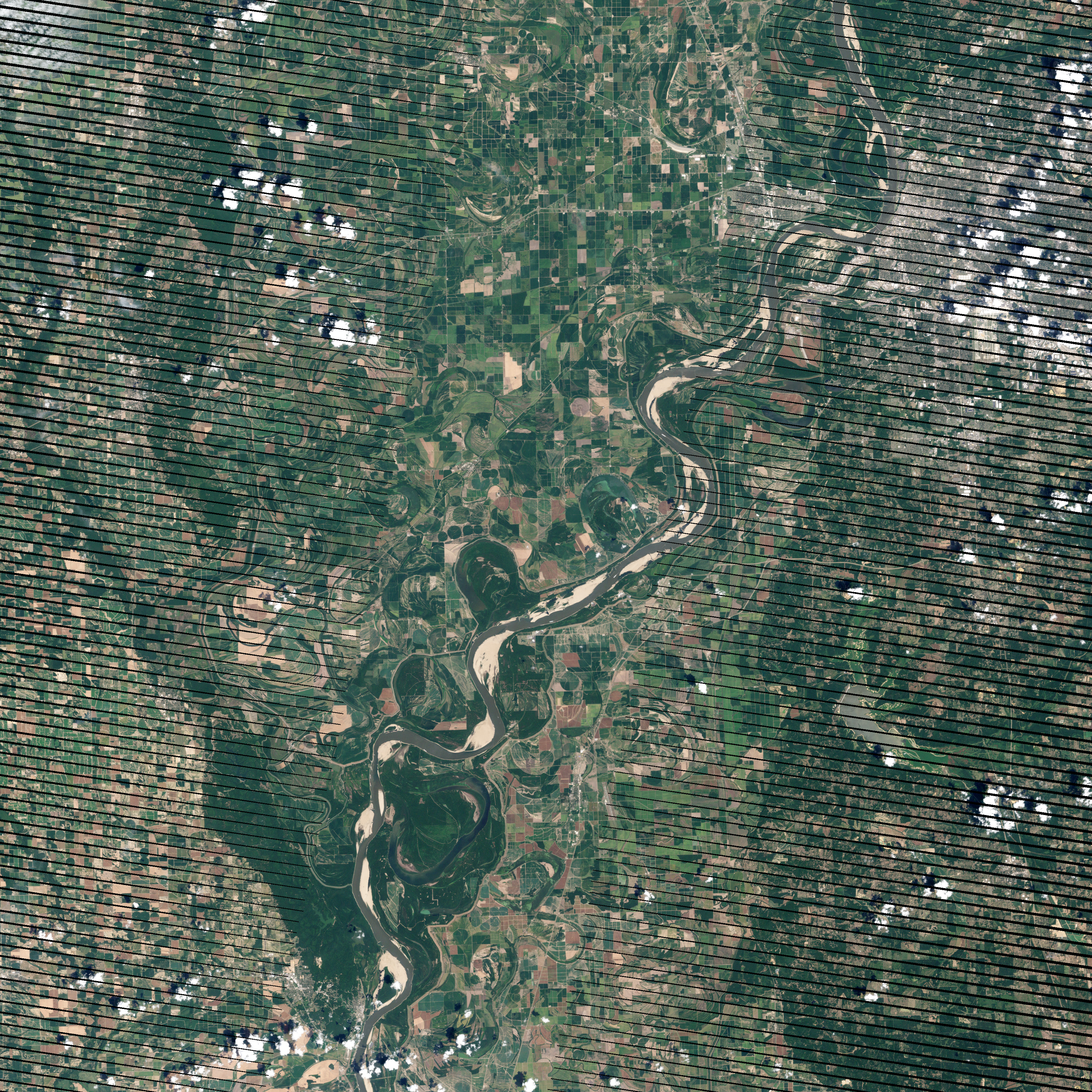
acquired August 8, 2012 download large image (5 MB, JPEG, 3170x3170 - left)
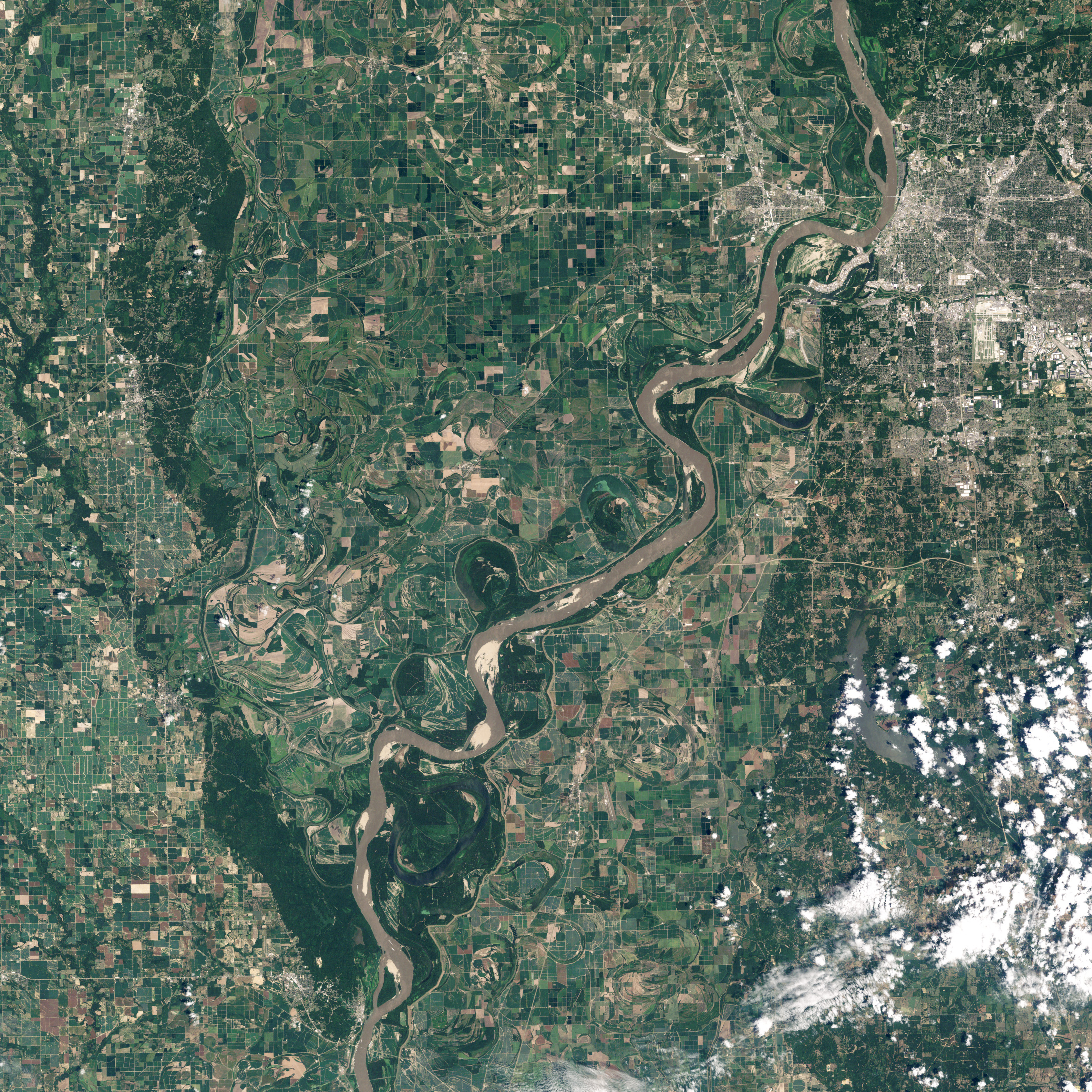
acquired August 14, 2011 download large image (5 MB, JPEG, 3170x3170 - right)
acquired August 14, 2011 - August 8, 2012 download Google Earth file (KML)
View Both Images
In the spring of 2011, the Mississippi River swelled to historic levels, rising out of its banks, rolling across a wide flood plain, and eating at flood barriers. The story in 2012 could not be more different: the river has reached record-low levels in places.
The contrast is illustrated in these two images, which show a stretch of the river just south of Memphis, Tennessee. Landsat 7 captured the top image on August 8, 2012, while Landsat 5 took the lower image on August 14, 2011. (The images are rotated so that north is to the left.) In the August 2011 image, the river was three months removed from the peak of the floods, and close to its normal level for the month. In August 2012, the river was several feet below the river stage for Memphis, and many sandbars were newly exposed or greatly expanded.
On August 17, 2012, water levels in the Memphis region were 2.4 to 8.3 feet below river stage. At the time of the August 2011 image (lower), the river was 11.7 feet above river stage. (In May 2011, the river peaked 56.6 feet above river stage in the same location.)
The Mississippi River is a major North American transit route, carrying goods to and from ports in New Orleans and Baton Rogue. The top image shows that low water levels have narrowed the river from a superhighway to a small road. The U.S. Army Corp of Engineers maintains a 9-foot shipping channel in the lower Mississippi and has dredges working around the clock to keep the channel clear. Not only are water levels low in 2012, but the floods of 2011 dropped a layer of sediment on the riverbed, reshaping previously open channels.
The reduced river flow in 2012 has translated into millions of dollars in extra shipping costs, as the loss of just one inch of draft means that a barge can carry 17 tons less than it otherwise would. The result is decreased shipping capacity.
Reduced water levels had one positive impact: The U.S. Army Corp of Engineers has been able to access and repair levees that were damaged in last year’s floods. The levees are the tan lines that surround the river in these images.
The low water levels followed record-setting temperatures and dry weather. By the end of July, 63 percent of the contiguous United States was in drought, affecting both crops and water supplies.
References
Advanced Hydrologic Prediction Service. (2012, August 17). Mississippi River at Memphis. NOAA National Weather Service. Accessed August 17, 2012.
Advanced Hydrologic Prediction Service. (2012, August 17). Mississippi River at Helena. NOAA National Weather Service. Accessed August 17, 2012.
American Waterways Operators. (2012, July 20). Nation’s waterways operators concerned about the impact of drought conditions, low water levels. Accessed August 17, 2012.
Mississippi National River and Recreation Area. (2012, August 1). Mississippi River Facts. National Park Service. Accessed August 17, 2012.
National Climate Data Center. (2012, August). State of the Climate National Overview for July 2012. NOAA. Accessed August 17, 2012.
U.S. Army Corps of Engineers. (2012, August 9). Communication, cooperation and coordination key to keeping Mississippi River open for commercial navigation. Accessed August 17, 2012.
U.S. Army Corps of Engineers. (2012, August 3). Mississippi-Ohio River confluence update. Accessed August 17, 2012.
Yang, J. (2012, August 15). Drought sends Mississippi into ‘uncharted territory.’ NBC News. Accessed August 17, 2012.
NASA Earth Observatory image created by Jesse Allen and Robert Simmon, using Landsat data provided by the United States Geological Survey. Caption by Holli Riebeek.


No comments:
Post a Comment